HydroLearn
Hydraulic Design using HEC-RAS: Coastal LA
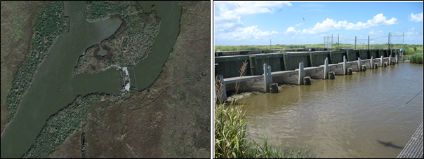
Sustained saltwater intrusion is one of the leading causes of marsh fragility and land loss in coastal Louisiana. A solution to mitigate salt water intrusion is freshwater introduction projects. The application of this type of restoration project usually involves the dredging or excavation of a new or existing channel to accommodate the additional freshwater flow. This module concentrates on constructing and utilizing a one-dimensional unsteady flow model to assist in the hydraulic design of a proposed conveyance channel. This module is based on an actual restoration project that was proposed is South Pecan Island located in Coastal Louisiana.
Problem Statement
Wetlands in Louisiana’s Chenier Plain are undergoing persistent deterioration that will become increasingly problematic if not adequately addressed. Many types of projects are proposed with the ultimate goal of protecting and/or restoring the wetlands. One such type of project is freshwater introduction aimed at decreasing the salinity levels within a marsh ecosystem. Sustained saltwater intrusion is one of the leading causes of marsh fragility and land loss in coastal Louisiana. In order to determine the potential impact and effectiveness of any given project, computer models are used to simulate the hydrology of the area both with and without the project. Understanding the theory behind the model as well as methods used to construct and evaluate the model is vital to implementing successful restoration activities.
Module Overview
This module is based on a case study of a fresh water introduction restoration project located near Pecan Island in Coastal Louisiana. Id concentrates on using a one-dimensional unsteady flow model to assist in the hydraulic design of a proposed conveyance channel.
Topics Covered
- Developing project area maps with QGIS
- Using RAS Mapper to create a geometry layer
- Modeling one-dimensional unsteady flow in HEC-RAS
- A simple project cost analysis
Learning Objectives
At the end of this case study, you should be able to:
- Explain the purpose and goals of the ME-23 restoration project
- Develop geometry files
- Implement the proposed hydraulic structure
- Conduct a one-dimensional unsteady flow analysis
- Analyze and interpret the design modifications to make informed engineering decisions
This will be accomplished through activities within each section. Results from each activity will be recorded in specified results templates. The results templates for each activity can be found at the beginning of each activity. The results templates are organized such that results from one activity can easily be used in successive activities.
Suggested Implentation Mode
The intent of this module is to introduce students to coastal restoration projects and the use of numerical models and data analysis to (a) assess the feasibility of the proposed project, and (b) perform hydraulic design analysis. The module is based on an actual restoration project that was proposed in the Pecan Island area in southwest Louisiana and concentrates on using a one-dimensional unsteady flow model to assist in the hydraulic design of a proposed conveyance channel. The design of the module is such that the students should be able to complete all activities on their own with no assistance from the Instructor. The Instructor may choose to implement the module with a fully hands-off approach and ask the students to submit their solutions at the end of the module.
Prerequisites
N/A
Course Authors
Robert Miller, PhD, PE
University of Louisiana at Lafayette. Contact: Robert.Miller@louisiana.edu
Matthew Deshotel
University of Louisiana at Lafayette Master's student graduate
Water Resources Engineer at Dewberry. Contact: MDeshotel@dewberry.com
Jenny Byrd, Graduate Research Assistant
University of Louisiana at Lafayette. Contact: C00074306@louisiana.edu
Emad Habib, PhD, PE
University of Louisiana at Lafayette. Contact: emad.habib@louisiana.edu
Target Audience
Junior/Senior Hydrology and Water Resources Engineering Courses
Tools Needed
Computer with access to Internet, Excel, free QGIS software, and free HEC-RAS software.
Course Sharing and Adaptation
This course is available for export by clicking the "Export Link" at the top right of this page. If you are an Instructor seeking the answer keys, please contact the course creators using your official University email account.
Make sure you cite the source of your new course (e.g., this course was adapted from Hydraulic Design using HEC-RAS: Coastal LA). You can include this citation on an "Adaptation Page" of your new course, in your course card, or in the introduction section of your new course.
Recommended Citation
Miller, R., Habib, E., Deshotel, M., Byrd, J. (2019) Hydraulic Design using HEC-RAS: Coastal LA. HydroLearn. https://edx.hydrolearn.org/courses/course-v1:HydroLearn+HydroLearn403-1+2019_S2/about
Expected Total Hours
A student could expect to complete this module with approximately 20 work hours.